
Thursday, April 5, 2012
New Section of Experimental Forest
So after seeing that map yesterday that I posted, I noticed in a small corner a portion of the CEF (Clemson Experimental Forest) that I had never ventured into, but had been close to many times. This portion in in between Old Central Road and Madden Bridge Road. The "Ingles" run that we call it with running club, which explores some of the central trails that I've posted before (here is the route) ends up on Old Central and then goes over until it reaches Hwy 93 (Old Greenville Hwy). Today I was feeling adventurous, and even though I had just run 7 trail miles yesterday, I decided to look for this mysterious dirt road that showed up in this area. Sure enough I found it off of mountain dale rd, and ventured down it. This road ended up being pretty awesome, basically it weaved between a couple of different power cuts heading towards the major power grid near downtown central. At one point I even crossed a pretty awesome creek in the middle of a field! All in all it was a crazy run and I ended up going farther than I had planned because I stuck with this road. Here is the route I ran today, and while it may not be a good mountain biking trail, it made for a quite adventurous run!
 This is the route of the power road, there were several others that branched off which I obviously didn't have the time (or stamina) to explore today
Wednesday, April 4, 2012
New Hi-Res Issaqueena Map

Monday, April 2, 2012
More Hart's Cove Power Roads
Went exploring while running again out near these power roads. There are some nice dirt roads back here, very extensive, it doesn't appear that any of them really go anywhere. There are some parts that end at the lake, so if you're looking for a nice lake hangout that few people would know about there are likely some good spots back here. Overall its nice if you want to do some nice downhills mountain biking or if you're just in an adventurous mood.
 This run goes farther north than the previous biking exploration below and there were a few trees down, and some of these roads weren't in great shape, especially the fart north part

Friday, March 16, 2012
BrOconee Power Roads
Went out exploring on my bike today, used my recently found power roads by the engineering testing facilities (west campus) to get to 123 and then cross it over to harts cove, where I had spied the entrance to some more power roads. Went biking all through some of these, but I was pressed for time so I ended up having to turn back way short of how far I wanted to go, but I managed to check out and map some of these roads on with my watch. Hoping to get back and there and even find a way to access the alledged rope swing in this area

Link to GPS projection of my ride
http://www.mapmyrun.com/routes/view/75523124
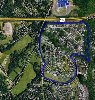
Section 6: Country Walk
Thursday, March 15, 2012
Section 5: West Campus


Wednesday, March 14, 2012
Section 4: North Clemson

These are some pretty awesome trails that very few people know about, and they're within running/biking distance to campus. Anyways, the one over to the west side of the map is part of a park with a boat drop that is quite popular among fishers. The park also has a decent Frisbee golf course, which the trail follows for a short while, then breaks off to continue around the penisula. This trail is a nice smooth and well maintained trail. Have never mountain biked, but I'd imagine you can get some nice speed on it.
The trail on the east side is a little harder to find. This trail begins in the middle of an apartment complex and was clearly made by people with mountain biking in mind. There is actually a much more vast network of trails that the one pictured, however I haven't taken too much time to explore the area. The trail begins with a gate blocking the entrance, there runs through the woods until it opens up a bit on what appears to be a very old fire road. the trail branches off and goes up hill for awhile until it reaches the highest point in the area. At this point you can follow the fire road back over to the road and cross the road onto an interesting network of trails (likely made by neighborhood kids). These trails are much more narrow and can be difficult to navigate, however they are very fun. On this first section of the trail there are sever mountain bike jumps built out of the mud in the area.
Subscribe to:
Comments (Atom)